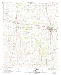
1968 Map of Uniontown West
USGS Topo · Published 1987About this map
Faunsdale and Uniontown anchor this section of the Alabama Black Belt, situated along the Southern railroad line during the late 1960s. The landscape is defined by its rural community structures, featuring a high concentration of country churches and family or community burial grounds such as St Michaels Cem and Cedar Grove Cem. Educational facilities like Faunsdale Jr High Sch and Hatch High Sch serve these concentrated settlements, while the surrounding acreage is marked by water features including Lake Roseland, Lake Meadwood, and the meandering Greer Creek. The presence of multiple flowing wells and a small Airfield near Uniontown suggests a landscape transitioning between traditional agriculture and modern infrastructure, all while maintaining the historic settlement patterns centered on small rail-side hubs and the rural hamlet of Siddonsville.
Find a feature on this map
36 named features on this map. Tap any name to fly to it.
Don’t see what you’re looking for? This feature index may not catch every label — zoom into the map to look around manually.
Map Details
Editions of this 1968 Uniontown West Map
3 editions found
Other maps of this area

1953 · Montgomery
USGS Topo · 1:250,000

1956 · Montgomery
USGS Topo · 1:250,000

1957 · Montgomery
USGS Topo · 1:250,000

1968 · Thomaston East
USGS Topo · 1:24,000

1968 · Uniontown West
USGS Topo · 1:24,000

1968 · Uniontown East
USGS Topo · 1:24,000

1968 · Thomaston West
USGS Topo · 1:24,000

1968 · Gallion
USGS Topo · 1:24,000

1968 · Central Mills
USGS Topo · 1:24,000

1979 · Scott Station
USGS Topo · 1:24,000