
1964 Map of Unionville West
USGS Topo · Published 1965About this map
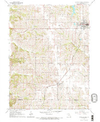
Unionville serves as the focal point of this northern Missouri landscape, situated near the northeastern corner of a terrain defined by the headwaters of several southern-flowing streams. The Chicago Burlington and Quincy railroad cuts a diagonal path from the northwest down through the settlement of Lemons, illustrating the vital transportation corridor that linked these rural communities to the wider regional economy. The map reveals a densely organized social fabric of the mid-20th century, where local life centered around rural educational and spiritual sites such as Triumph Sch, Good Hope Sch, and Bethany Ch.
Find a feature on this map
30 named features on this map. Tap any name to fly to it.
Don’t see what you’re looking for? This feature index may not catch every label — zoom into the map to look around manually.
Map Details
Editions of this 1964 Unionville West Map
2 editions found
Other maps of this area

1912 · Green City
USGS Topo · 1:62,500

1914 · Green City
USGS Topo · 1:62,500

1939 · Centerville
USGS Topo · 1:62,500

1941 · Centerville
USGS Topo · 1:62,500

1942 · Seymour
USGS Topo · 1:62,500

1944 · Seymour
USGS Topo · 1:62,500

1954 · Centerville
USGS Topo · 1:250,000

1957 · Centerville
USGS Topo · 1:250,000

1958 · Centerville
USGS Topo · 1:250,000

1964 · Pollock NW
USGS Topo · 1:24,000