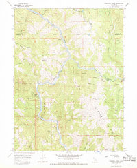
1967 Map of Updegraff Ridge
USGS Topo · Published 1969About this map
The Eel River carves a winding path through this corner of the Emerald Triangle, defining the boundary between Trinity and Mendocino counties. The landscape is dominated by the Northwestern Pacific Railroad, which follows the river's tight bends and steep canyons, connecting remote points like Bell Springs and Spyrock. This era shows the intricate tract divisions of the Round Valley Indian Reservation, with the Treaty Boundary clearly delineated across the rugged terrain.
Find a feature on this map
29 named features on this map. Tap any name to fly to it.
Don’t see what you’re looking for? This feature index may not catch every label — zoom into the map to look around manually.
Map Details
Editions of this 1967 Updegraff Ridge Map
3 editions found
Other maps of this area

1920 · Cummings
USGS Topo · 1:62,500

1920 · Covelo
USGS Topo · 1:62,500

1920 · Harris
USGS Topo · 1:62,500

1921 · Hoaglin
USGS Topo · 1:62,500

1922 · Island Mountain
USGS Topo · 1:62,500

1931 · Hoaglin
USGS Topo · 1:96,000

1935 · Hoaglin
USGS Topo · 1:125,000

1949 · Alderpoint
USGS Topo · 1:62,500

1951 · Alderpoint
USGS Topo · 1:62,500

1952 · Spyrock
USGS Topo · 1:62,500