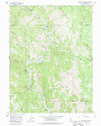
1967 Map of Updegraff Ridge
USGS Topo · Published 1985About this map
The Northwestern Pacific railroad tracks follow the serpentine course of the Eel River through this isolated stretch of Mendocino and Trinity counties, where the canyon walls rise sharply toward Updegraff Ridge. During the mid-1960s, this landscape was defined by remote outposts such as Spyrock and Bell Springs, which served as vital connections for the surrounding cattle ranches. The map documents the extensive reach of the Round Valley Indian Reservation, with its boundary lines and numbered tracts cutting across the steep terrain of Island Mountain. Local life centered on established holdings like Island Mountain Ranch and Big Bend Ranch, while the interior remains accessible primarily by jeep trails. This survey captures the region just as the traditional ranching economy and the railroad still dictated the rhythm of these river canyons before modern shifts in transit and land use.
Find a feature on this map
29 named features on this map. Tap any name to fly to it.
Don’t see what you’re looking for? This feature index may not catch every label — zoom into the map to look around manually.
Map Details
Editions of this 1967 Updegraff Ridge Map
3 editions found
Other maps of this area

1920 · Cummings
USGS Topo · 1:62,500

1920 · Covelo
USGS Topo · 1:62,500

1920 · Harris
USGS Topo · 1:62,500

1921 · Hoaglin
USGS Topo · 1:62,500

1922 · Island Mountain
USGS Topo · 1:62,500

1931 · Hoaglin
USGS Topo · 1:96,000

1935 · Hoaglin
USGS Topo · 1:125,000

1949 · Alderpoint
USGS Topo · 1:62,500

1951 · Alderpoint
USGS Topo · 1:62,500

1952 · Spyrock
USGS Topo · 1:62,500