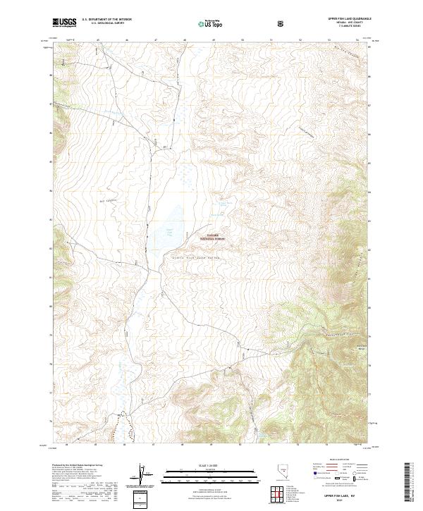
2021 Map of Upper Fish Lake
USGS Topo · Published 2021About this map
Little Fish Lake Valley serves as the central drainage for this high-elevation Great Basin landscape, situated within the eastern reaches of the Toiyabe National Forest. The presence of Upper Fish Lake and several vital water sources like Upper Warm Spring and Pott Hole Spring indicates the critical role of riparian zones in this arid environment. The eastern boundary is defined by the sharp rise of the Hot Creek Range, featuring distinctive geomorphological formations such as the Crescent Hogback. Historic access and movement through the terrain are traced along the Clover Creek Trl and Fandangos Trl, which navigate the various canyons including Green Monster Canyon and Cottonwood Canyon. This mapping reflects a modern assessment of a landscape shaped by both ephemeral watercourses and permanent springs.
Find a feature on this map
29 named features on this map. Tap any name to fly to it.
Don’t see what you’re looking for? This feature index may not catch every label — zoom into the map to look around manually.
Map Details
Editions of this 2021 Upper Fish Lake Map
This is the sole edition of this map. No revisions or reprints were ever made.
Other maps of this area

1956 · Tonopah
USGS Topo · 1:250,000

1959 · Tonopah
USGS Topo · 1:250,000

1962 · Tonopah
USGS Topo · 1:250,000

1967 · Upper Fish Lake
USGS Topo · 1:24,000

1967 · Morey Peak
USGS Topo · 1:24,000

1968 · Morey Peak
USGS Topo · 1:62,500

1968 · Fish Springs
USGS Topo · 1:62,500
1968 · Fish Springs SE
USGS Topo · 1:24,000
1968 · Fish Springs
USGS Topo · 1:24,000
1968 · Hobble Canyon
USGS Topo · 1:24,000