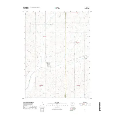
2018 Map of Ute
USGS Topo · Published 2018About this map
Ute serves as the central hub of this West Central Iowa landscape, situated at the junction where several drainages converge. The town's grid is detailed with street names like S Monona Ave and Railway St, reflecting its historical reliance on the rail corridor. Just north of the settlement, the Saint Marys Cem and Saint Clairce Cem provide significant points of interest for genealogists tracing local lineage.
Find a feature on this map
54 named features on this map. Tap any name to fly to it.
Don’t see what you’re looking for? This feature index may not catch every label — zoom into the map to look around manually.
Map Details
Editions of this 2018 Ute Map
This is the sole edition of this map. No revisions or reprints were ever made.
Other maps of this area

1954 · Omaha
USGS Topo · 1:250,000

1954 · Fort Dodge
USGS Topo · 1:250,000

1957 · Omaha
USGS Topo · 1:250,000

1957 · Fort Dodge
USGS Topo · 1:250,000

1958 · Omaha
USGS Topo · 1:250,000

1958 · Fort Dodge
USGS Topo · 1:250,000

1969 · Danbury
USGS Topo · 1:24,000

1969 · Mapleton
USGS Topo · 1:24,000
1971 · Mapleton SE
USGS Topo · 1:24,000

1971 · Ricketts
USGS Topo · 1:24,000