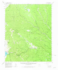
1955 Map of Ute Park
USGS Topo · Published 1981About this map
The northern Sangre de Cristo Mountains and the expansive Beaubien and Miranda (Maxwell Grant) define this mid-century survey of the high-country landscape. Gold mining history is deeply etched into the terrain north of Baldy Mountain, where the Deep Tunnel Mine, French Henry Mine, and Aztec Mine mark the legacy of the Moreno Valley gold rush. The map documents the transition of these peaks from industrial mining and ranching to a premier recreational landscape, particularly through the establishment of the Philmont Scout Ranch. Numerous backcountry outposts like Dan Beard Trail Camp and Ponil Base Camp are scattered across the mesas and canyons, while the settlement at Ute Park serves as a central hub along the Cimarron River. Evidence of early homesteading and mining camps remains visible through labels like Virginia City (Aband) and family-named sites such as Atmore Ranch and the Jackson Cemetery.
Find a feature on this map
76 named features on this map. Tap any name to fly to it.
Don’t see what you’re looking for? This feature index may not catch every label — zoom into the map to look around manually.
Map Details
Editions of this 1955 Ute Park Map
5 editions found

Other maps of this area

1954 · Raton
USGS Topo · 1:250,000

1955 · Cimarron
USGS Topo · 1:62,500

1955 · Ute Park
USGS Topo · 1:62,500

1956 · Tooth Of Time
USGS Topo · 1:62,500

1956 · Miami
USGS Topo · 1:62,500

1958 · Raton
USGS Topo · 1:250,000

1962 · Ash Mountain
USGS Topo · 1:62,500

1962 · Casa Grande
USGS Topo · 1:62,500

1963 · Eagle Nest
USGS Topo · 1:24,000

1963 · Red River Pass
USGS Topo · 1:24,000