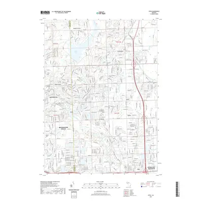
2019 Map of Utica
USGS Topo · Published 2019About this map
The Clinton River and its various tributaries, including the Middle Br Clinton River, anchor the landscape of this suburban Macomb and Oakland County corridor. In 2019, the area reflects a modern residential and recreational network built atop early agricultural settlements. The Macomb Orchard Rail Trail follows a historical rail corridor through the heart of the sheet, connecting towns like Washington and Shelby. This survey captures the preservation of the past through numerous burial grounds, such as Mount Vernon Cem and the Saint Lawrence Cem, alongside larger recreational features like Stony Creek Lake. The transition from the more established streets of Utica and Sterling Heights in the south to the open spaces around Mount Vernon in the north reveals the ongoing suburban development of the region. Local landmarks like the Quarry near Stony Creek and the Old Canal trace the area's industrial and hydraulic history.
Find a feature on this map
47 named features on this map. Tap any name to fly to it.
Don’t see what you’re looking for? This feature index may not catch every label — zoom into the map to look around manually.
Map Details
Editions of this 2019 Utica Map
This is the sole edition of this map. No revisions or reprints were ever made.
Other maps of this area

1908 · Rochester
USGS Topo · 1:62,500

1912 · Mt Clemens
USGS Topo · 1:62,500

1914 · Armada
USGS Topo · 1:62,500

1928 · Armada
USGS Topo · 1:62,500

1929 · Mt Clemens
USGS Topo · 1:62,500

1936 · Warren
USGS Topo · 1:31,680

1936 · Birmingham
USGS Topo · 1:31,680

1936 · Rochester
USGS Topo · 1:31,680

1936 · Washington
USGS Topo · 1:31,680

1936 · Waldenburg
USGS Topo · 1:31,680
Featured Places
- Sterling Heights, MI
- Shelby Charter Township, MI
- Rochester Hills, MI
- Washington Charter Township, MI
- Oakland Charter Township, MI