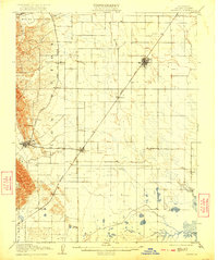
1908 Map of Vacaville
USGS Topo · Published 1922About this map
The Southern Pacific and its Southern Pacific Line form the industrial backbone of this Solano County corridor, linking agricultural hubs like Vacaville and Dixon. While the western edge is defined by the elevation of the Vaca Mountains, the landscape quickly flattens into an intricate network of waterways and sloughs. Evidence of early resource extraction is visible through a noted Gas Well and a Cement Mill near the southern edge of the survey. The settlement of Maine Prairie sits at the edge of the wetlands, marking a transition toward the tidal influences of Cache Slough and Hass Slough. This 1906 survey captures a specific moment in the California interior when rail-dependent towns like Elmira and Batavia served as vital junctions for the surrounding orchards and grain fields, long before the modern expansion of the Interstate system.
Find a feature on this map
30 named features on this map. Tap any name to fly to it.
Don’t see what you’re looking for? This feature index may not catch every label — zoom into the map to look around manually.
Map Details
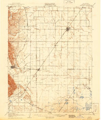
Editions of this 1908 Vacaville Map
3 editions found
Other maps of this area

1896 · Carquinez Strait
USGS Topo · 1:62,500

1898 · Karquines
USGS Topo · 1:62,500

1901 · Karquines
USGS Topo · 1:62,500

1902 · Napa
USGS Topo · 1:125,000

1907 · Woodland
USGS Topo · 1:62,500

1907 · Davisville
USGS Topo · 1:62,500

1907 · Antioch
USGS Topo · 1:62,500

1908 · Vacaville
USGS Topo · 1:62,500

1908 · Courtland
USGS Topo · 1:62,500

1908 · Antioch
USGS Topo · 1:62,500