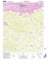
2002 Map of Valdese
USGS Topo · Published 2003About this map
Valdese and its neighboring towns of Drexel, Rutherford College, and Connelly Springs anchor the northern corridor of this landscape. The settlement pattern here follows the established rail and road infrastructure, giving way to the complex topography of the South Mountains to the south. The transition from industrial and residential centers to the more isolated terrain of Prospect Ridge and Long Mountain illustrates the area's physical divide between the valley floor and the rising foothills.
Find a feature on this map
58 named features on this map. Tap any name to fly to it.
Don’t see what you’re looking for? This feature index may not catch every label — zoom into the map to look around manually.
Map Details
Editions of this 2002 Valdese Map
This is the sole edition of this map. No revisions or reprints were ever made.
Other maps of this area

1895 · Hickory
USGS Topo · 1:125,000

1905 · Morganton
USGS Topo · 1:125,000

1953 · Charlotte
USGS Topo · 1:250,000

1954 · Charlotte
USGS Topo · 1:250,000

1956 · Valdese
USGS Topo · 1:24,000

1956 · Benn Knob
USGS Topo · 1:24,000

1956 · Morganton North
USGS Topo · 1:24,000

1956 · Casar
USGS Topo · 1:24,000

1956 · Morganton South
USGS Topo · 1:24,000

1956 · Drexel
USGS Topo · 1:24,000