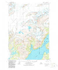
1960 Map of Valdez A-8
USGS Topo · Published 1987About this map
The Columbia Glacier dominates the western landscape of this 1960 survey, illustrating a massive glacial system long before the significant retreats observed in later decades. The terrain is a complex network of ice and water within the Chugach National Forest, featuring the distinct Great Nunatak and the ice-carved waters of Valdez Arm. To the east, the maritime importance of the region is evident through the deep-water passage of the Valdez Narrows and the sheltered Jack Bay. Named summits like Mount Thomas and Mount Cameron rise above active ice fields, including the Shoup Glacier and Anderson Glacier. The map captures a critical point of northern topography where the Valdez corporate boundary meets the rugged coastal wilderness, preserving the state of the coastline at Tongue Pt and Potato Pt as they appeared prior to modern shifts in glacial and sea-level dynamics.
Find a feature on this map
34 named features on this map. Tap any name to fly to it.
Don’t see what you’re looking for? This feature index may not catch every label — zoom into the map to look around manually.
Map Details
Editions of this 1960 Valdez A-8 Map
3 editions found

Other maps of this area

1948 · Cordova
USGS Topo · 1:250,000

1950 · Cordova D-7
USGS Topo · 1:63,360

1951 · Seward
USGS Topo · 1:250,000

1951 · Anchorage
USGS Topo · 1:250,000

1951 · Cordova
USGS Topo · 1:250,000

1951 · Seward D-1
USGS Topo · 1:63,360

1951 · Cordova D-8
USGS Topo · 1:63,360

1952 · Valdez
USGS Topo · 1:250,000

1952 · Seward D-1
USGS Topo · 1:63,360

1952 · Cordova D-8
USGS Topo · 1:63,360