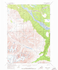
1951 Map of Valdez B-1
USGS Topo · Published 1973About this map
The Chitina River serves as the dominant waterway in this mid-century survey, joined by the Kuskulana River in an intricate network of glacial runoff and mountain streams. Tracing the northern bank of the river, the Old Railroad Grade provides a clear record of the region’s early industrial transport infrastructure, once vital for moving copper and supplies through the Copper River valley.
Find a feature on this map
19 named features on this map. Tap any name to fly to it.
Don’t see what you’re looking for? This feature index may not catch every label — zoom into the map to look around manually.
Map Details
Editions of this 1951 Valdez B-1 Map
2 editions found
Other maps of this area

1950 · McCarthy A-8
USGS Topo · 1:63,360

1951 · McCarthy
USGS Topo · 1:250,000

1951 · Valdez B-2
USGS Topo · 1:63,360

1951 · Valdez B-1
USGS Topo · 1:63,360

1951 · Valdez A-1
USGS Topo · 1:63,360

1951 · McCarthy C-8
USGS Topo · 1:63,360

1951 · Valdez C-2
USGS Topo · 1:63,360

1951 · McCarthy B-8
USGS Topo · 1:63,360

1951 · Valdez C-1
USGS Topo · 1:63,360

1951 · Valdez A-2
USGS Topo · 1:63,360