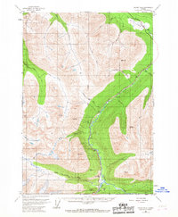
1951 Map of Valdez B-4
USGS Topo · Published 1967About this map
The Richardson Highway provides the primary corridor through this high-altitude landscape in the early 1950s, following the narrow valleys carved by the Tiekel River and Tsina River. The map captures a critical point in the region's transport history, showing the highway's path as it winds past roadside landmarks like Tiekel Cache and the small settlement of Tiekel. Surveyed before the era of modern Alaskan infrastructure, this 1951 sheet records the exact placement of isolated structures such as a Cabin near the confluence of Stuart Creek and several geodetic survey markers like VABM Rice atop Rice Mtn. The terrain is defined by steep glacial valleys and named water bodies including Glacier Creek and Mill Creek, illustrating the glacial drainage patterns that shaped the Copper River Basin's geography.
Find a feature on this map
31 named features on this map. Tap any name to fly to it.
Don’t see what you’re looking for? This feature index may not catch every label — zoom into the map to look around manually.
Map Details
Editions of this 1951 Valdez B-4 Map
4 editions found
Other maps of this area

1950 · Valdez A-3
USGS Topo · 1:63,360

1951 · Valdez B-3
USGS Topo · 1:63,360

1951 · Valdez B-5
USGS Topo · 1:63,360

1951 · Valdez C-3
USGS Topo · 1:63,360

1951 · Valdez C-4
USGS Topo · 1:63,360

1951 · Valdez B-4
USGS Topo · 1:63,360

1951 · Valdez C-5
USGS Topo · 1:63,360

1952 · Valdez
USGS Topo · 1:250,000

1953 · Valdez C-3
USGS Topo · 1:63,360

1953 · Valdez B-4
USGS Topo · 1:63,360