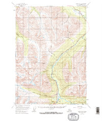
1951 Map of Valdez B-4
USGS Topo · Published 1967About this map
The Richardson Highway provides the primary corridor through this high-altitude landscape, following the deep valleys of the Tiekel River and Tsina River. This 1951 survey, which includes revisions from 1966, shows a wilderness punctuated by small roadside outposts and mining infrastructure. The small settlement at Richardson and the isolated Tiekel Cache reflect the early infrastructure of the Valdez-Fairbanks trail system.
Find a feature on this map
23 named features on this map. Tap any name to fly to it.
Don’t see what you’re looking for? This feature index may not catch every label — zoom into the map to look around manually.
Map Details
Editions of this 1951 Valdez B-4 Map
4 editions found
Other maps of this area

1950 · Valdez A-3
USGS Topo · 1:63,360

1951 · Valdez B-3
USGS Topo · 1:63,360

1951 · Valdez B-5
USGS Topo · 1:63,360

1951 · Valdez C-3
USGS Topo · 1:63,360

1951 · Valdez C-4
USGS Topo · 1:63,360

1951 · Valdez B-4
USGS Topo · 1:63,360

1951 · Valdez C-5
USGS Topo · 1:63,360

1952 · Valdez
USGS Topo · 1:250,000

1953 · Valdez C-3
USGS Topo · 1:63,360

1953 · Valdez B-4
USGS Topo · 1:63,360