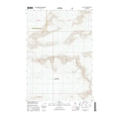
2016 Map of Valdez B-8 NW
USGS Topo · Published 2016About this map
The vast Columbia Glacier system dominates the southern portion of this high-elevation Alaska landscape, showing the complex ice and drainage patterns within the Chugach National Forest. This 2016 survey captures the high peaks that separate these ice fields, including Mt Haley, Flat Top Peak, and Mt Powder Top. The map reveals the critical divide where ice flows toward the Nelchina Glacier to the north and the Tazlina Glacier to the east. These glacial features are presented alongside the administrative boundary separating the Matanuska-Susitna Borough from the Valdez-Cordova Census Area, providing a precise record of the remote terrain's topography and ice coverage at the time of the study.
Find a feature on this map
8 named features on this map. Tap any name to fly to it.
Don’t see what you’re looking for? This feature index may not catch every label — zoom into the map to look around manually.
Map Details
Editions of this 2016 Valdez B-8 NW Map
This is the sole edition of this map. No revisions or reprints were ever made.
Other maps of this area

1951 · Anchorage
USGS Topo · 1:250,000

1952 · Valdez
USGS Topo · 1:250,000

1960 · Anchorage B-1
USGS Topo · 1:63,360

1960 · Valdez B-8
USGS Topo · 1:63,360

1960 · Valdez C-8
USGS Topo · 1:63,360

1960 · Anchorage C-1
USGS Topo · 1:63,360

1960 · Valdez
USGS Topo · 1:250,000

1962 · Anchorage
USGS Topo · 1:250,000

1979 · Anchorage
USGS Topo · 1:250,000
1993 · Valdez C-8
USGS Topo · 1:63,360