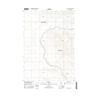
2016 Map of Valdez C-1 NW
USGS Topo · Published 2016About this map
The Kotsina River carves a deep valley through this Alaskan wilderness, marking a distinct boundary between the Wrangell-Saint Elias National Preserve and the Wrangell-Saint Elias National Park. Elevation reaches its height at Hubbard Peak, overlooking a network of drainages including Willow Cr and Rabbit Cr. The landscape is defined by its dramatic relief, with contours tracing steep slopes that lead down to the braided river channels. This survey documents the preserved territory in the early 21st century, showing the intersection of several township boundaries including t2s r6e and t2s r7e. The absence of roads or permanent settlements emphasizes the protected status of these federal lands, where narrow tributaries like Elliott Cr and Kushina Cr flow from high-altitude snowmelt into the primary river system.
Find a feature on this map
14 named features on this map. Tap any name to fly to it.
Don’t see what you’re looking for? This feature index may not catch every label — zoom into the map to look around manually.
Map Details
Editions of this 2016 Valdez C-1 NW Map
This is the sole edition of this map. No revisions or reprints were ever made.
Other maps of this area

1951 · Valdez C-2
USGS Topo · 1:63,360

1951 · Valdez C-1
USGS Topo · 1:63,360

1952 · Valdez
USGS Topo · 1:250,000

1953 · Valdez C-2
USGS Topo · 1:63,360

1953 · Valdez C-1
USGS Topo · 1:63,360

1959 · Valdez D-2
USGS Topo · 1:63,360

1959 · Valdez D-1
USGS Topo · 1:63,360

1960 · Valdez
USGS Topo · 1:250,000
1996 · Valdez D-1
USGS Topo · 1:63,360

1996 · Valdez C-2
USGS Topo · 1:63,360