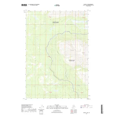
2019 Map of Valdez C-1 NW
USGS Topo · Published 2019About this map
The Wrangell-St. Elias National Preserve and adjacent Wrangell-St. Elias National Park dominate this interior Alaskan landscape, which is defined by the high elevations of the Wrangell Mountains. The terrain is deeply incised by a network of drainage systems, including Willow Cr and Rabbit Cr, which feed into larger water bodies. Central to the area's movement and geography is the Kotsina River, accompanied by the winding Kotsina River Trail. This path follows the river valley through the mountains, providing a historical route of travel through the glaciated terrain.
Find a feature on this map
16 named features on this map. Tap any name to fly to it.
Don’t see what you’re looking for? This feature index may not catch every label — zoom into the map to look around manually.
Map Details
Editions of this 2019 Valdez C-1 NW Map
This is the sole edition of this map. No revisions or reprints were ever made.
Other maps of this area

1951 · Valdez C-2
USGS Topo · 1:63,360

1951 · Valdez C-1
USGS Topo · 1:63,360

1952 · Valdez
USGS Topo · 1:250,000

1953 · Valdez C-2
USGS Topo · 1:63,360

1953 · Valdez C-1
USGS Topo · 1:63,360

1959 · Valdez D-2
USGS Topo · 1:63,360

1959 · Valdez D-1
USGS Topo · 1:63,360

1960 · Valdez
USGS Topo · 1:250,000
1996 · Valdez D-1
USGS Topo · 1:63,360

1996 · Valdez C-2
USGS Topo · 1:63,360