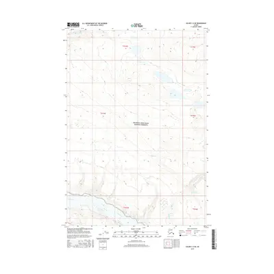
2016 Map of Valdez C-2 NE
USGS Topo · Published 2016About this map
The Wrangell-Saint Elias National Preserve encompasses the majority of this territory, where the wild drainage patterns of the Copper Basin are captured in high detail. The Copper River flows along the southern edge of the quadrangle, serving as the primary hydrological anchor for the region. Numerous glacial and snow-fed tributaries, including Horse Cr and Rabbit Cr, descend from the higher elevations to the north and east to join the main river system. The presence of the Cheshnina River in the northwest corner highlights the complex network of braided streams and creek beds that define this remote Alaskan landscape. This 2016 survey illustrates the pristine state of the preserve, emphasizing the natural topography and the absence of established road infrastructure or permanent settlements within these specific township boundaries.
Find a feature on this map
12 named features on this map. Tap any name to fly to it.
Don’t see what you’re looking for? This feature index may not catch every label — zoom into the map to look around manually.
Map Details
Editions of this 2016 Valdez C-2 NE Map
This is the sole edition of this map. No revisions or reprints were ever made.
Other maps of this area

1951 · Valdez C-2
USGS Topo · 1:63,360

1951 · Valdez C-1
USGS Topo · 1:63,360

1952 · Valdez
USGS Topo · 1:250,000

1953 · Valdez C-2
USGS Topo · 1:63,360

1953 · Valdez C-1
USGS Topo · 1:63,360

1959 · Valdez D-2
USGS Topo · 1:63,360

1959 · Valdez D-1
USGS Topo · 1:63,360

1960 · Valdez
USGS Topo · 1:250,000
1996 · Valdez D-1
USGS Topo · 1:63,360

1996 · Valdez C-2
USGS Topo · 1:63,360