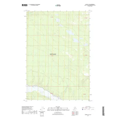
2019 Map of Valdez C-2 NE
USGS Topo · Published 2019About this map
Wrangell-St. Elias National Preserve encompasses the vast majority of this landscape, where the high-altitude terrain is defined by complex glacial drainage systems. The powerful Copper River cuts through the southern portion of the quadrangle, serving as the primary basin for several glacial and mountain streams. Fed by the heights to the north and east, the Cheshnina River and Horse Cr demonstrate the intricate hydrology of the Alaska Range's southern slopes. This 2019 survey documents a wilderness largely untouched by permanent settlement, where the movement of water—from the Rabbit Cr to the Kuslina Cr—dictates the geography. The map provides a precise record of these glacial watercourses and their relationship to the established township and range boundaries of the Valdez-Cordova region.
Find a feature on this map
13 named features on this map. Tap any name to fly to it.
Don’t see what you’re looking for? This feature index may not catch every label — zoom into the map to look around manually.
Map Details
Editions of this 2019 Valdez C-2 NE Map
This is the sole edition of this map. No revisions or reprints were ever made.
Other maps of this area

1951 · Valdez C-2
USGS Topo · 1:63,360

1951 · Valdez C-1
USGS Topo · 1:63,360

1952 · Valdez
USGS Topo · 1:250,000

1953 · Valdez C-2
USGS Topo · 1:63,360

1953 · Valdez C-1
USGS Topo · 1:63,360

1959 · Valdez D-2
USGS Topo · 1:63,360

1959 · Valdez D-1
USGS Topo · 1:63,360

1960 · Valdez
USGS Topo · 1:250,000
1996 · Valdez D-1
USGS Topo · 1:63,360

1996 · Valdez C-2
USGS Topo · 1:63,360