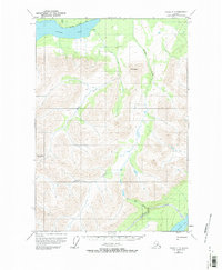
1951 Map of Valdez C-5
USGS Topo · Published 1975About this map
Klutina Lake dominates the northern landscape of this interior terrain, where the Mahlo River and Chitina Creek feed into its expansive waters. The survey captures a region defined by high peaks and remote waterways, with elevations rising sharply to Mt Simpson and Bence Mtn. Human presence is minimal, noted only by a lone Cabin and a designated Trail skirting the northern shoreline of the lake. To the southeast, the drainage patterns shift toward Tonsina Lake, connected via Greyling Creek and the smaller Twin Lake. The lack of established roads or settlements in this 1950s documentation emphasizes the wilderness character of the Copper River Meridian, as identified by the Bureau of Land Management. Researchers can trace the natural catchments of Manker Creek and other unnamed tributaries as they carve through the high-elevation topography.
Find a feature on this map
11 named features on this map. Tap any name to fly to it.
Don’t see what you’re looking for? This feature index may not catch every label — zoom into the map to look around manually.
Map Details
Editions of this 1951 Valdez C-5 Map
3 editions found
Other maps of this area

1948 · Valdez D-5
USGS Topo · 1:63,360

1949 · Valdez D-4
USGS Topo · 1:63,360

1949 · Valdez D-6
USGS Topo · 1:63,360

1950 · Valdez C-6
USGS Topo · 1:63,360

1951 · Valdez D-5
USGS Topo · 1:63,360

1951 · Valdez D-6
USGS Topo · 1:63,360

1951 · Valdez B-5
USGS Topo · 1:63,360

1951 · Valdez C-4
USGS Topo · 1:63,360

1951 · Valdez B-4
USGS Topo · 1:63,360

1951 · Valdez C-5
USGS Topo · 1:63,360