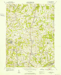
1950 Map of Valencia
USGS Topo · Published 1952About this map
The Butler Co and Allegheny Co border cuts through this 1950 landscape, a region defined by small crossroads settlements and developing institutional sites. Valencia and Bakerstown serve as primary hubs, with the Baltimore and Ohio railroad corridor linking the valley communities. The map highlights several notable charitable and medical institutions of the mid-century era, such as St Barnabas Home and Lillian Home Heart House, reflecting the area's transition toward suburban healthcare and social services.
Find a feature on this map
37 named features on this map. Tap any name to fly to it.
Don’t see what you’re looking for? This feature index may not catch every label — zoom into the map to look around manually.
Map Details
Editions of this 1950 Valencia Map
5 editions found
Other maps of this area

1906 · Sewickley
USGS Topo · 1:62,500

1908 · Sewickley
USGS Topo · 1:62,500

1908 · New Kensington
USGS Topo · 1:62,500

1908 · Zelienople
USGS Topo · 1:62,500

1909 · Butler
USGS Topo · 1:62,500

1910 · New Kensington
USGS Topo · 1:62,500

1910 · Zelienople
USGS Topo · 1:62,500

1911 · Butler
USGS Topo · 1:62,500

1950 · Valencia
USGS Topo · 1:24,000

1951 · Canton
USGS Topo · 1:250,000