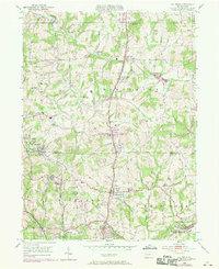
1950 Map of Valencia
USGS Topo · Published 1970About this map
The industrial and social landscape of northern Allegheny and southern Butler counties comes into focus on this 1950s-era survey, updated via 1969 aerial photography. The Pennsylvania Turnpike cuts through the terrain, contrasting with the established rail infrastructure of the Baltimore and Ohio and the Bessemer and Lake Erie railroads. In the southeast corner, the settlement of Bairdford and its associated Mine Dump reveal the local importance of coal mining during this period. Institutional landmarks like the St Barnabas Home and the Lilian Home Rest House are clearly marked, alongside scattered country schoolhouses such as Conley School No 1 and Galbreath School No 2. These features, along with early church sites like Trinity Ch, provide a grounded look at the community fabric as it transitioned from rural traditions toward the suburban expansion of the late 20th century.
Find a feature on this map
36 named features on this map. Tap any name to fly to it.
Don’t see what you’re looking for? This feature index may not catch every label — zoom into the map to look around manually.
Map Details
Editions of this 1950 Valencia Map
5 editions found
Other maps of this area

1906 · Sewickley
USGS Topo · 1:62,500

1908 · Sewickley
USGS Topo · 1:62,500

1908 · New Kensington
USGS Topo · 1:62,500

1908 · Zelienople
USGS Topo · 1:62,500

1909 · Butler
USGS Topo · 1:62,500

1910 · New Kensington
USGS Topo · 1:62,500

1910 · Zelienople
USGS Topo · 1:62,500

1911 · Butler
USGS Topo · 1:62,500

1950 · Valencia
USGS Topo · 1:24,000

1951 · Canton
USGS Topo · 1:250,000