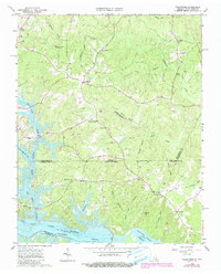
1963 Map of Valentines
USGS Topo · Published 1990About this map
The Virginia-North Carolina border line bisects this landscape, separating Brunswick County from Northampton County. The terrain is defined by the expansive waters of Lake Gaston and the Roanoke River, with the northern reaches of Roanoke Rapids Lake visible at the southern edge. Inland, the community of Valentines serves as a local hub, connected to smaller outposts like Bowens Corner and Henrico.
Find a feature on this map
43 named features on this map. Tap any name to fly to it.
Don’t see what you’re looking for? This feature index may not catch every label — zoom into the map to look around manually.
Map Details
Editions of this 1963 Valentines Map
4 editions found
Other maps of this area

1919 · White Plains
USGS Topo · 1:48,000

1919 · Emporia
USGS Topo · 1:62,500

1920 · White Plains
USGS Topo · 1:62,500

1942 · Emporia
USGS Topo · 1:62,500

1953 · Norfolk
USGS Topo · 1:250,000

1963 · Powellton
USGS Topo · 1:24,000

1963 · Barley
USGS Topo · 1:24,000

1963 · Gasburg
USGS Topo · 1:24,000

1963 · Ante
USGS Topo · 1:24,000

1963 · Valentines
USGS Topo · 1:24,000