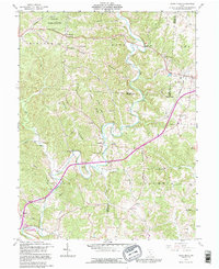
1992 Map of Vales Mills
USGS Topo · Published 1995About this map
Raccoon Creek winds through a landscape of narrow hollows and high ridges in Vinton County, following a path that supported early milling sites like Vales Mills and Bolins Mills. The terrain is characterized by prominent elevations such as Knox Ridge and Union Ridge, which served as the logical paths for early roadways and small community centers. Genealogists will find a wealth of family-named landmarks and rural institutions, including Harkins Chapel, Putnam Chapel, and the Wilton Sch. The map also captures the industrial footprint of the region through scattered Oil Wells, gas wells, and mines, indicating a long-standing reliance on extractive resources. To the northwest, the edge of Zaleski State Forest provides a look at the transition from settled agricultural and timber land into state-managed forest conservation.
Find a feature on this map
50 named features on this map. Tap any name to fly to it.
Don’t see what you’re looking for? This feature index may not catch every label — zoom into the map to look around manually.
Map Details
Editions of this 1992 Vales Mills Map
This is the sole edition of this map. No revisions or reprints were ever made.
Other maps of this area

1903 · Athens
USGS Topo · 1:62,500

1904 · Zaleski
USGS Topo · 1:62,500

1905 · Athens
USGS Topo · 1:62,500

1905 · Wilkesville
USGS Topo · 1:62,500

1907 · Pomeroy
USGS Topo · 1:62,500

1907 · Zaleski
USGS Topo · 1:62,500

1908 · Wilkesville
USGS Topo · 1:62,500

1947 · Columbus
USGS Topo · 1:250,000

1960 · Albany
USGS Topo · 1:24,000

1960 · Rutland
USGS Topo · 1:24,000