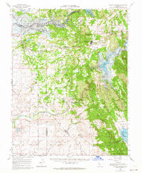
1962 Map of Valley Springs
USGS Topo · Published 1964About this map
Mokelumne River and Calaveras River drainage basins define the landscape of western Calaveras County in this early 1960s study. The transition to a water-managed future is captured by blue hatching marking land slated for inundation by the Camanche Reservoir and New Hogan Reservoir. This era of massive hydrological change threatens old river-bottom settlements like Camanche and Lancha Plana, which sit near extensive tailings from earlier gold mining operations. Industry and agriculture are clearly delineated, from the Penn Mine and McCarty Mine to sprawling family-named holdings like Stone Corral Ranch and Bocabella Ranch. The Southern Pacific rail line serves as a central artery for transportation, connecting the small junctions of Burson (Helisma Sta) and Valley Springs as they navigate the foothill terrain between Gopher Ridge and the Bear Mountains.
Find a feature on this map
54 named features on this map. Tap any name to fly to it.
Don’t see what you’re looking for? This feature index may not catch every label — zoom into the map to look around manually.
Map Details
Editions of this 1962 Valley Springs Map
2 editions found
Other maps of this area

1889 · Jackson
USGS Topo · 1:125,000

1892 · Jackson
USGS Topo · 1:125,000

1894 · Lodi
USGS Topo · 1:125,000

1897 · Jackson
USGS Topo · 1:125,000

1902 · Jackson
USGS Topo · 1:125,000

1908 · Linden
USGS Topo · 1:31,680

1909 · Goose Creek
USGS Topo · 1:31,680

1909 · Clements
USGS Topo · 1:31,680

1915 · Trigo
USGS Topo · 1:31,680

1915 · Peters
USGS Topo · 1:31,680