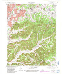
1982 Map of Valley Station
USGS Topo · Published 1988About this map
The ridges and hollows of the Jefferson County Memorial Forest dominate the southern landscape of this 1980s-era topographic survey, where steep terrain like Mitchell Hill and Potato Knob transitions into the growing suburbs of southern Jefferson County. Along the Dixie Hwy corridor, residential developments like Prairie Village and Valley Gardens expand near the industrial presence of Johnsontown. The map reveals the deep-rooted local history of the area through family-named landmarks and cemeteries, including the Risinger Cem, Horine Cem, and McDaniel Cem. Institutional footprints are clearly marked, from the campus of Southwest Jefferson Community College to the southern edge of the Fort Knox Mil Res at the Bullitt County line. This update includes purple revisions documenting residential growth and utility changes like the Sewage Disposal sites and power infrastructure near Windsor Park.
Find a feature on this map
112 named features on this map. Tap any name to fly to it.
Don’t see what you’re looking for? This feature index may not catch every label — zoom into the map to look around manually.
Map Details
Editions of this 1982 Valley Station Map
4 editions found
Other maps of this area

1907 · Louisville
USGS Topo · 1:62,500

1909 · Kosmosdale
USGS Topo · 1:48,000

1912 · Kosmosdale
USGS Topo · 1:62,500

1936 · Vine Grove
USGS Topo · 1:62,500

1943 · Vine Grove
USGS Topo · 1:62,500

1946 · Pitts Point
USGS Topo · 1:24,000

1946 · Fort Knox
USGS Topo · 1:24,000

1946 · Vine Grove
USGS Topo · 1:62,500

1949 · Shepherdsville
USGS Topo · 1:24,000

1949 · Shepherdsville
USGS Topo · 1:62,500