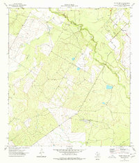
1974 Map of Valley Wells
USGS Topo · Published 1977About this map
The Nueces River winds through this Dimmit County landscape, defining a region where cattle ranching and petroleum extraction coexist. The map captures the mid-1970s development of the Good Luck Oil Field, evidenced by a dense network of unimproved roads leading to numerous Oil Wells and a Drill Hole. Settlement is concentrated at Valley Wells in the northeast, while the Diamond H Ranch stands as a significant landmark in the southern interior, complete with private Landing Strips. The hydrological character of the brush country is visible in the seasonal flow of Appurceon Creek and San Roque Creek, as well as the presence of Buckhorn Lake near the riverbanks.
Find a feature on this map
12 named features on this map. Tap any name to fly to it.
Don’t see what you’re looking for? This feature index may not catch every label — zoom into the map to look around manually.
Map Details
Editions of this 1974 Valley Wells Map
This is the sole edition of this map. No revisions or reprints were ever made.
Other maps of this area

1925 · San Roque Lake 1-a
USGS Topo · 1:48,000

1927 · Bart
USGS Topo · 1:62,500

1929 · Cotulla
USGS Topo · 1:125,000

1932 · Valley Wells
USGS Topo · 1:62,500

1939 · Big Wells
USGS Topo · 1:62,500

1940 · Catarina
USGS Topo · 1:62,500

1940 · Artesia Wells
USGS Topo · 1:62,500

1953 · Crystal City
USGS Topo · 1:250,000

1955 · Crystal City
USGS Topo · 1:250,000

1956 · Woodward
USGS Topo · 1:62,500