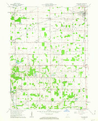
1962 Map of Van Buren
USGS Topo · Published 1963About this map
Van Buren serves as the primary hub in this corner of Grant County, anchored by the New York Chicago and St Louis Railroad and the Masonic Cem. The surrounding landscape is defined by a dense network of drainage ditches and small creeks like Lugar Creek and Walnut Creek, which support the agricultural tracts of Washington, Center, and Monroe townships. Smaller settlements and rural intersections like Landess, Hanfield, and Dooville appear alongside local landmarks such as Fletcher Ch and Antioch Ch.
Find a feature on this map
53 named features on this map. Tap any name to fly to it.
Don’t see what you’re looking for? This feature index may not catch every label — zoom into the map to look around manually.
Map Details
Editions of this 1962 Van Buren Map
2 editions found
Other maps of this area

1950 · Warren
USGS Topo · 1:24,000

1950 · Mount Etna
USGS Topo · 1:24,000

1951 · Mount Etna
USGS Topo · 1:24,000

1952 · Warren
USGS Topo · 1:24,000

1953 · La Fontaine
USGS Topo · 1:24,000

1953 · Muncie
USGS Topo · 1:250,000

1956 · Muncie
USGS Topo · 1:250,000

1960 · Fairmount
USGS Topo · 1:24,000

1960 · Gas City
USGS Topo · 1:24,000

1960 · Hartford City West
USGS Topo · 1:24,000