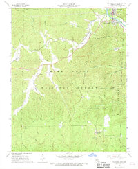
1968 Map of Van Buren South
USGS Topo · Published 1969About this map
The Current River serves as the primary corridor for settlement in this 1960s Ozark landscape, where the town of Van Buren and its neighbor South Van Buren are established alongside the St Louis-San Francisco railroad line. The map highlights a transition from riverside commerce to the heavily timbered interior of the Mark Twain National Forest. A network of hollows, such as Secesh Hollow and Poca Hollow, dictates the rural road patterns and settlement locations within Carter County. Fire detection is a visible priority across these wooded ridges, evidenced by the presence of the Eagle Lookout Tower, Big Spring Lookout Tower, and Eastwood Lookout Tower. Local history is preserved in several family and community landmarks, including Turley Cem, the Dry Valley Ch, and the small community of Eastwood near the southern boundary of the quadrangle.
Find a feature on this map
48 named features on this map. Tap any name to fly to it.
Don’t see what you’re looking for? This feature index may not catch every label — zoom into the map to look around manually.
Map Details
Editions of this 1968 Van Buren South Map
This is the sole edition of this map. No revisions or reprints were ever made.
Other maps of this area

1928 · Cardareva
USGS Topo · 1:62,500

1943 · Ellington
USGS Topo · 1:62,500

1944 · Van Buren
USGS Topo · 1:62,500

1944 · Grandin
USGS Topo · 1:62,500

1945 · Ellington
USGS Topo · 1:62,500

1946 · Grandin
USGS Topo · 1:62,500

1946 · Van Buren
USGS Topo · 1:62,500

1949 · Rolla
USGS Topo · 1:250,000

1949 · Cardareva
USGS Topo · 1:62,500

1953 · Rolla
USGS Topo · 1:250,000