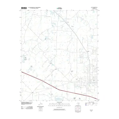
2010 Map of Van
USGS Topo · Published 2010About this map
The Van Oil Field anchors the eastern edge of this landscape, reflecting the long-standing petroleum heritage of the region. This 2010 survey illustrates a rural-industrial balance, where the developing town of Van sits amidst a network of older settlements like Colfax, Pruitt, and Jones. The southern portion of the quadrangle is defined by the course of the Neches River and its tributaries, including Glade Branch and Pole Branch. Genealogists will find several burial grounds preserved here, such as Pace Cemetery, Oakes Cemetery, and Marvin Chapel Cemetery, which mark the early social centers of these communities. Water management is a visible priority across the terrain, evidenced by numerous small impoundments like Metzger Lake, Rhine Lake, and Poco Lake, along with a series of engineered structures such as Metzger Dam Number 1 and Poco Club Dam.
Find a feature on this map
81 named features on this map. Tap any name to fly to it.
Don’t see what you’re looking for? This feature index may not catch every label — zoom into the map to look around manually.
Map Details
Editions of this 2010 Van Map
This is the sole edition of this map. No revisions or reprints were ever made.
Other maps of this area

1948 · Brownsboro
USGS Topo · 1:62,500

1948 · Martins Mill
USGS Topo · 1:62,500

1949 · Martins Mill
USGS Topo · 1:62,500

1949 · Brownsboro
USGS Topo · 1:62,500

1956 · Tyler
USGS Topo · 1:250,000

1959 · Golden
USGS Topo · 1:24,000

1959 · Grand Saline
USGS Topo · 1:24,000

1959 · Van
USGS Topo · 1:24,000

1959 · Van Lake
USGS Topo · 1:24,000

1959 · Grand Saline
USGS Topo · 1:62,500