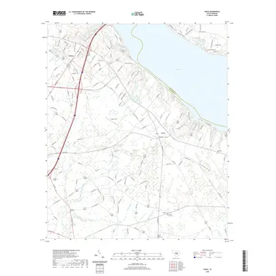
2020 Map of Vance
USGS Topo · Published 2020About this map
Lake Marion defines the northern edge of this landscape, its expansive shoreline meeting the southern reaches of Clarendon County and the town of Santee. The map reveals a transition from the structured residential development near the lake to the wetland systems of the coastal plain, characterized by Horse Range Swamp and Target Swamp. For those tracing local family history, several small burial grounds are documented across the rural interior, including Bell Cem, Felder Cem, and Springfield Cem. Transportation routes such as Vance Rd and the Old State Rd weave through the region, connecting the settlement of Santee to outlying areas near Avinger Field. Significant water features like Batchelor Br and Webbs Cr illustrate the complex drainage patterns that have historically shaped the land use and agricultural development of this part of Orangeburg County.
Find a feature on this map
125 named features on this map. Tap any name to fly to it.
Don’t see what you’re looking for? This feature index may not catch every label — zoom into the map to look around manually.
Map Details
Editions of this 2020 Vance Map
This is the sole edition of this map. No revisions or reprints were ever made.
Other maps of this area

1920 · Eutawville
USGS Topo · 1:48,000

1920 · Bowman
USGS Topo · 1:48,000

1921 · Bowman
USGS Topo · 1:62,500

1921 · Eutawville
USGS Topo · 1:62,500

1943 · Bowman
USGS Topo · 1:62,500

1943 · Orangeburg
USGS Topo · 1:125,000

1943 · Eutawville
USGS Topo · 1:62,500

1946 · Elloree
USGS Topo · 1:62,500

1954 · Augusta
USGS Topo · 1:250,000

1957 · Augusta
USGS Topo · 1:250,000