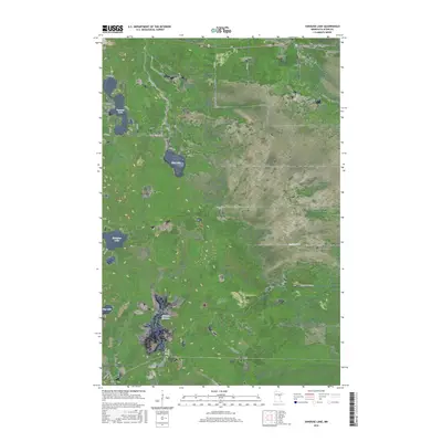
2016 Map of Vanduse Lake
USGS Topo · Published 2016About this map
Vanduse Lake and Hay Lake anchor a landscape defined by an extensive network of wetlands and small waterways in this northern Aitkin County study. The terrain is characterized by a low-lying, water-rich environment where the Cornish Flowage and the meandering path of Sixteen Cr dominate the southern and eastern reaches. Human imprint is visible primarily through a grid of local roads and trails such as Edblad Rd, Haylake Rd, and the Hedbom Forest Trl, which navigate between the marshes and timber. The map reflects a modern era of land management, showing how local transit routes like Loon Ave and 657th Ln skirt the edges of Blackface Lake and other basins, preserving the hydrological character of this portion of the Minnesota Northwoods.
Find a feature on this map
22 named features on this map. Tap any name to fly to it.
Don’t see what you’re looking for? This feature index may not catch every label — zoom into the map to look around manually.
Map Details
Editions of this 2016 Vanduse Lake Map
This is the sole edition of this map. No revisions or reprints were ever made.
Other maps of this area

1953 · Duluth
USGS Topo · 1:250,000

1954 · Hibbing
USGS Topo · 1:250,000

1957 · Hibbing
USGS Topo · 1:250,000

1958 · Hibbing
USGS Topo · 1:250,000

1958 · Duluth
USGS Topo · 1:250,000

1964 · Hibbing
USGS Topo · 1:250,000

1969 · Wawina
USGS Topo · 1:24,000

1969 · Island
USGS Topo · 1:24,000

1970 · Little Prairie Lake
USGS Topo · 1:24,000
1970 · Swan River
USGS Topo · 1:24,000