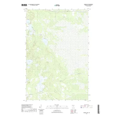
2019 Map of Vanduse Lake
USGS Topo · Published 2019About this map
Vanduse Lake and Hay Lake anchor a landscape defined by extensive wetland systems and dense timber in this modern survey of Aitkin County. The terrain is crisscrossed by a network of local access routes including Edblad Rd and Haylake Rd, reflecting the remote, water-rich character of central Minnesota. Significant tracts of marshland are drained by Sixteen Cr, which flows through the eastern portion of the quadrangle. In the southern reaches, the Hedbom Forest Trl provides passage through managed woodlands, while the Cornish Flowage and Bay Lake highlight the area's intricate hydrology. This data, compiled from recent sources including the National Hydrography Dataset and the National Elevation Dataset, documents the persistent natural boundaries of the northern forest before any future environmental shifts.
Find a feature on this map
23 named features on this map. Tap any name to fly to it.
Don’t see what you’re looking for? This feature index may not catch every label — zoom into the map to look around manually.
Map Details
Editions of this 2019 Vanduse Lake Map
This is the sole edition of this map. No revisions or reprints were ever made.
Other maps of this area

1953 · Duluth
USGS Topo · 1:250,000

1954 · Hibbing
USGS Topo · 1:250,000

1957 · Hibbing
USGS Topo · 1:250,000

1958 · Hibbing
USGS Topo · 1:250,000

1958 · Duluth
USGS Topo · 1:250,000

1964 · Hibbing
USGS Topo · 1:250,000

1969 · Wawina
USGS Topo · 1:24,000

1969 · Island
USGS Topo · 1:24,000

1970 · Little Prairie Lake
USGS Topo · 1:24,000
1970 · Swan River
USGS Topo · 1:24,000