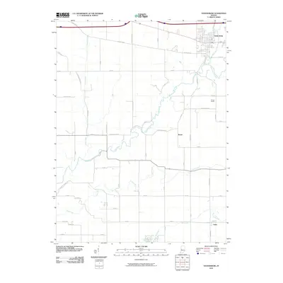
2010 Map of Veedersburg
USGS Topo · Published 2010About this map
Veedersburg serves as the primary hub in this portion of Fountain County, where the street grid is bisected by the meandering course of Coal Creek and its tributary, Dry Run. The landscape is defined by a dense network of country roads, including the historic W Dixie Bee Rd and W Cades Hollow Rd, which connect smaller settlements like Mackie and Yeddo. The drainage patterns of Prairie Creek and Graham Creek illustrate the natural topography that has influenced agricultural land use and local development for generations. To the south, Lake Holiday Hide-away and the waters of Mill Creek provide a distinct contrast to the surrounding farmland. The presence of Songer Airport near W New Century Rd highlights the continued local infrastructure in this rural corridor, while the confluence of the East Fork Coal Creek near the town center underscores the importance of the regional watershed.
Find a feature on this map
46 named features on this map. Tap any name to fly to it.
Don’t see what you’re looking for? This feature index may not catch every label — zoom into the map to look around manually.
Map Details
Editions of this 2010 Veedersburg Map
This is the sole edition of this map. No revisions or reprints were ever made.
Other maps of this area

1948 · Wallace
USGS Topo · 1:24,000

1953 · Danville
USGS Topo · 1:250,000

1953 · Indianapolis
USGS Topo · 1:250,000

1955 · Danville
USGS Topo · 1:250,000

1955 · Kingman
USGS Topo · 1:24,000
1955 · Newport
USGS Topo · 1:24,000

1956 · Danville
USGS Topo · 1:250,000

1956 · Indianapolis
USGS Topo · 1:250,000

1957 · Indianapolis
USGS Topo · 1:250,000

1958 · Stonebluff
USGS Topo · 1:24,000