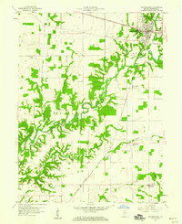
1958 Map of Veedersburg
USGS Topo · Published 1959About this map
Coal Creek winds through the heart of this landscape, its deep-cut valley floor contrasting with the upland farms of Wabash and Troy townships. In the late 1950s, Veedersburg serves as the primary municipal hub, positioned at the junction of the New York Central and the Chicago and St Louis railroads. To the east, the smaller settlements of Sterling and Chambersburg are clearly delineated near the East Fork of Coal Creek.
Find a feature on this map
24 named features on this map. Tap any name to fly to it.
Don’t see what you’re looking for? This feature index may not catch every label — zoom into the map to look around manually.
Map Details
Editions of this 1958 Veedersburg Map
This is the sole edition of this map. No revisions or reprints were ever made.
Other maps of this area

1948 · Wallace
USGS Topo · 1:24,000

1953 · Danville
USGS Topo · 1:250,000

1953 · Indianapolis
USGS Topo · 1:250,000

1955 · Danville
USGS Topo · 1:250,000

1955 · Kingman
USGS Topo · 1:24,000
1955 · Newport
USGS Topo · 1:24,000

1956 · Danville
USGS Topo · 1:250,000

1956 · Indianapolis
USGS Topo · 1:250,000

1957 · Indianapolis
USGS Topo · 1:250,000

1958 · Stonebluff
USGS Topo · 1:24,000