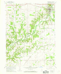
1967 Map of Veedersburg
USGS Topo · Published 1968About this map
Veedersburg serves as the primary hub of this Fountain County landscape, where the Norfolk and Western railway and major local thoroughfares intersect. The terrain is defined by the winding course of Coal Creek and its many tributaries, such as Graham Creek and East Fork Coal Creek. This mid-century survey reveals a rural society structured around local townships like Wabash and Fulton, with landmarks including the Fairgrounds and several Gravel Pits reflecting the area's agricultural and industrial base. Small community centers and rural school sites such as Rabb Sch and churches like Cooper Chapel and New Century Ch are scattered across the township grid, providing critical location markers for genealogists and local historians. To the south, the settlement of Yeddo marks another point of interest near the banks of Mill Creek.
Find a feature on this map
33 named features on this map. Tap any name to fly to it.
Don’t see what you’re looking for? This feature index may not catch every label — zoom into the map to look around manually.
Map Details
Editions of this 1967 Veedersburg Map
This is the sole edition of this map. No revisions or reprints were ever made.
Other maps of this area

1948 · Wallace
USGS Topo · 1:24,000

1953 · Danville
USGS Topo · 1:250,000

1953 · Indianapolis
USGS Topo · 1:250,000

1955 · Danville
USGS Topo · 1:250,000

1955 · Kingman
USGS Topo · 1:24,000
1955 · Newport
USGS Topo · 1:24,000

1956 · Danville
USGS Topo · 1:250,000

1956 · Indianapolis
USGS Topo · 1:250,000

1957 · Indianapolis
USGS Topo · 1:250,000

1958 · Stonebluff
USGS Topo · 1:24,000