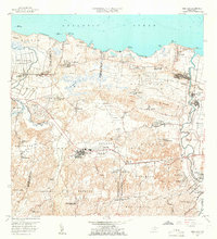
1958 Map of Vega Alta
USGS Topo · Published 1966About this map
Vega Alta serves as a central hub on this northern Puerto Rico landscape, situated at the base of the karst limestone foothills that define the Espinosa and Maguayo regions. To the north, the coastal plains are marked by the Aeropuerto de Dorado and the industrial presence of Central San Vicente, while the Rio Cibuco winds through the alluvial lowlands of Bajura. The transportation network is in a period of transition, with the Antigua Via del Ferrocarril tracing an older economic path across the terrain near Dorado. Local social infrastructure is well-documented, from the Escuela Industrial Para Mujeres to the Iglesia del Sagrado Corazon. Along the Atlantic coast, prominent features like Laguna Mata Redonda and the beaches at Cerro Gordo reflect the interface between the maritime environment and the developed interior settlements of Toa Baja and Higuillar.
Find a feature on this map
85 named features on this map. Tap any name to fly to it.
Don’t see what you’re looking for? This feature index may not catch every label — zoom into the map to look around manually.
Map Details
Editions of this 1958 Vega Alta Map
2 editions found
Other maps of this area

1940 · Vega Alta
USGS Topo · 1:30,000

1941 · Bayamon
USGS Topo · 1:30,000

1942 · Manati
USGS Topo · 1:30,000

1946 · Corozal
USGS Topo · 1:30,000

1946 · Ciales
USGS Topo · 1:30,000

1946 · Vega Alta
USGS Topo · 1:30,000

1946 · Naranjito
USGS Topo · 1:30,000

1946 · Manati
USGS Topo · 1:30,000

1947 · Corozal NO
USGS Topo · 1:10,000
1947 · Corozal NE
USGS Topo · 1:10,000