
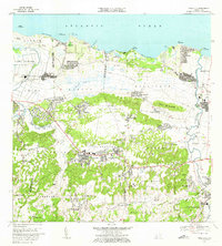
1969 Map of Vega Alta
USGS Topo · Published 1989About this map
The sugar economy of late 1960s Puerto Rico is evident in the industrial footprints of Central San Vicente and Central Constance, which anchored the local agricultural landscape during this era. Centered on the town of Vega Alta, this survey reveals a region transitioning between its plantation roots and mid-century modernization, marked by the Aeropuerto de Dorado and several coastal golf courses near the Atlantic Ocean. The interior is defined by the winding paths of the Río Cibuco and Río de la Plata, where the floodplain topography influenced the placement of barrios like Sabana and Espinosa. Genealogists and local historians can locate specific institutional landmarks, including the Escuela Industrial Para Mujeres and the Iglesia del Sagrado Corazón, alongside smaller rural schools such as the Escuela Candelaria Afuera and Escuela Segunda Unidad de Maricao Afuera.
Find a feature on this map
87 named features on this map. Tap any name to fly to it.
Don’t see what you’re looking for? This feature index may not catch every label — zoom into the map to look around manually.
Map Details
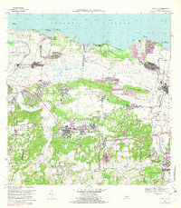
Editions of this 1969 Vega Alta Map
3 editions found
Other maps of this area

1940 · Vega Alta
USGS Topo · 1:30,000

1941 · Bayamon
USGS Topo · 1:30,000

1942 · Manati
USGS Topo · 1:30,000

1946 · Corozal
USGS Topo · 1:30,000

1946 · Ciales
USGS Topo · 1:30,000

1946 · Vega Alta
USGS Topo · 1:30,000

1946 · Naranjito
USGS Topo · 1:30,000

1946 · Manati
USGS Topo · 1:30,000

1947 · Corozal NO
USGS Topo · 1:10,000
1947 · Corozal NE
USGS Topo · 1:10,000