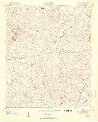
1950 Map of Verdery
USGS Topo · Published 1950About this map
Sumter National Forest land dominates this 1950 South Carolina landscape, where the confluence of numerous family-named branches and creeks defines the local geography. The area is a dense network of spiritual and educational centers, including Cedar Springs Church, Glover Chapel, and Long Cane Sch, which served the scattered agrarian population. These landmarks, often situated near watercourses like Long Cane Creek and Stillhouse Branch, reveal a community organized around rural crossroads and river crossings.
Find a feature on this map
54 named features on this map. Tap any name to fly to it.
Don’t see what you’re looking for? This feature index may not catch every label — zoom into the map to look around manually.
Map Details
Editions of this 1950 Verdery Map
2 editions found

Other maps of this area

1892 · Mc Cormick
USGS Topo · 1:125,000

1892 · Abbeville
USGS Topo · 1:125,000

1912 · Mc Cormick
USGS Topo · 1:125,000

1948 · Abbeville East
USGS Topo · 1:24,000

1948 · Verdery
USGS Topo · 1:24,000

1948 · Abbeville West
USGS Topo · 1:24,000

1949 · Abbeville
USGS Topo · 1:24,000

1949 · Calhoun Creek
USGS Topo · 1:24,000

1949 · Greenwood
USGS Topo · 1:24,000

1950 · Bradley
USGS Topo · 1:24,000
Featured Places
- Clatworthy Crossroads, SC
- Cedar Springs, SC
- Bradley Corner, SC
- Abbeville County, SC
- Greenwood County, SC