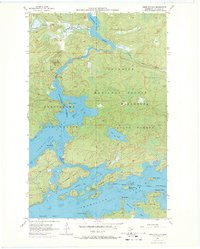
1956 Map of Vermilion Dam
USGS Topo · Published 1971About this map
The Vermilion Dam Lookout Tower stands as a sentinel over this wilderness landscape at the northern edge of the Superior National Forest. This 1950s survey, updated with 1969 aerial photography, reveals the intricate shoreline of the northern reaches of Vermilion Lake. The map details the water management and navigation infrastructure of the era, including the Gaging Station Vermilion Dam and the primary Vermilion River outflow. Numerous islands such as Hinsdale Island, Oak Island, and Knotts Island dot the bays, connected by narrow passages like Oak Narrows and Birch Narrows. The terrain is characterized by a dense network of water bodies within the Minnesota State Forest, where the complex geometry of Smart Bay, Wolf Bay, and Black Duck Bay defined the local geography for researchers and outdoorsmen alike before more modern developments altered the shorelines.
Find a feature on this map
36 named features on this map. Tap any name to fly to it.
Don’t see what you’re looking for? This feature index may not catch every label — zoom into the map to look around manually.
Map Details
Editions of this 1956 Vermilion Dam Map
5 editions found
Other maps of this area

1954 · Hibbing
USGS Topo · 1:250,000

1954 · International Falls
USGS Topo · 1:250,000

1956 · Sioux Pine Island
USGS Topo · 1:24,000

1956 · Tower
USGS Topo · 1:24,000

1956 · Vermilion Dam
USGS Topo · 1:24,000

1956 · Lost Lake
USGS Topo · 1:24,000

1957 · Hibbing
USGS Topo · 1:250,000

1957 · International Falls
USGS Topo · 1:250,000

1958 · International Falls
USGS Topo · 1:250,000

1958 · Hibbing
USGS Topo · 1:250,000