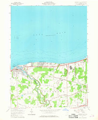
1959 Map of Vermilion East
USGS Topo · Published 1968About this map
The Vermilion River carves a winding path toward the Lake Erie shoreline, defining the local geography as it flows through Brownhelm Township. This mid-century survey reveals a coastal landscape transitioning from the established town of Vermilion into growing lakefront communities like Elberta Beach and Vermilion-on-the-Lake. The interior is characterized by a dense network of family-named roads, including Kneisel Road and Darrow Road, which connected rural farmsteads to spiritual and civic centers like Brownhelm Ch and its associated Brownhelm Cem. Industrial and transport footprints are prominent, with the New York Central and Chicago and St Louis railroads running parallel to the coast, while the modern Ohio Turnpike cuts across the southern reach. The presence of a Quarry near the Black River on the eastern edge points to the region's active extractive history during this era.
Find a feature on this map
40 named features on this map. Tap any name to fly to it.
Don’t see what you’re looking for? This feature index may not catch every label — zoom into the map to look around manually.
Map Details
Editions of this 1959 Vermilion East Map
2 editions found
Other maps of this area

1901 · Oberlin
USGS Topo · 1:62,500

1903 · Vermilion
USGS Topo · 1:62,500

1903 · Oberlin
USGS Topo · 1:62,500

1956 · Toledo
USGS Topo · 1:250,000

1959 · Berlin Heights
USGS Topo · 1:24,000

1959 · Vermilion East
USGS Topo · 1:24,000

1959 · Vermilion West
USGS Topo · 1:24,000

1959 · Kipton
USGS Topo · 1:24,000

1960 · Oberlin
USGS Topo · 1:24,000
1960 · Lorain
USGS Topo · 1:24,000