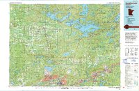
1994 Map of Vermillion Lake
USGS Topo · Published 1994About this map
Vermilion Lake and the northern reaches of the Mesabi Iron Range dominate this mid-1990s landscape in St. Louis County. The map documents the industrial footprint of the region, where extensive Mines, a large Tailings Pond, and Mine Dumps contrast with the protected wilderness of the Superior National Forest and the Boundary Waters Canoe Area. The city of Virginia serves as a primary hub, while the Duluth Missabe & Iron Range RR corridor traces the movement of ore through towns like Biwabik, McKinley, and Aurora. To the north, the complex shoreline of Vermilion Lake is detailed with features like Fraser Bay, Wolf Bay, and Oak Narrows. This survey captures the coexistence of heavy industry and northern forest recreation, including Tower-Soudan State Park and the widely dispersed rural settlements of Embarrass, Angora, and Linden Grove.
Find a feature on this map
145 named features on this map. Tap any name to fly to it.
Don’t see what you’re looking for? This feature index may not catch every label — zoom into the map to look around manually.
Map Details
Editions of this 1994 Vermillion Lake Map
This is the sole edition of this map. No revisions or reprints were ever made.
Other maps of this area

1933 · Ely
USGS Topo · 1:62,500

1939 · Ely
USGS Topo · 1:62,500

1949 · Aurora
USGS Topo · 1:24,000

1949 · Isaac Lake
USGS Topo · 1:24,000

1949 · Allen
USGS Topo · 1:24,000

1949 · Embarrass
USGS Topo · 1:24,000

1950 · Isaac Lake
USGS Topo · 1:24,000

1950 · Embarrass
USGS Topo · 1:24,000

1950 · Allen
USGS Topo · 1:24,000

1950 · Aurora
USGS Topo · 1:24,000