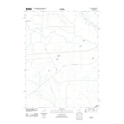
2012 Map of Verne
USGS Topo · Published 2012About this map
Verne sits at a geographic crossroads in this southwestern Wyoming landscape, where the meandering paths of Blacks Fork and Hams Fork converge. The terrain is defined by a series of named draws and hollows, such as Porter Hollow and Telephone Draw, which illustrate the complex drainage patterns feeding into the river system. This 2012 survey captures the modern infrastructure overlaying the high desert, specifically the junction of Moxa Arch Rd and Co Hwy 233.
Find a feature on this map
14 named features on this map. Tap any name to fly to it.
Don’t see what you’re looking for? This feature index may not catch every label — zoom into the map to look around manually.
Map Details
Editions of this 2012 Verne Map
This is the sole edition of this map. No revisions or reprints were ever made.
Other maps of this area

1954 · Ogden
USGS Topo · 1:250,000

1954 · Rock Springs
USGS Topo · 1:250,000

1958 · Ogden
USGS Topo · 1:250,000

1958 · Rock Springs
USGS Topo · 1:250,000

1960 · Ogden
USGS Topo · 1:250,000

1961 · Sevenmile Gulch
USGS Topo · 1:24,000

1961 · Granger
USGS Topo · 1:24,000

1962 · Rock Springs
USGS Topo · 1:250,000

1964 · Antelope Knoll
USGS Topo · 1:24,000
1964 · Wildcat Butte
USGS Topo · 1:24,000