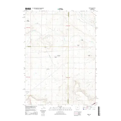
2015 Map of Verne
USGS Topo · Published 2015About this map
Blacks Fork and Hams Fork converge in this high-desert landscape, defining the hydrology of a region where Lincoln, Uinta, and Sweetwater counties meet. The settlement of Verne sits near the county lines, while Rocky Crossing provides a named landmark to the northwest along the winding path of Dry Muddy Cr. The terrain is deeply etched by a network of drainage features, including Bruff Draw, Telephone Draw, and Caterpillar Draw, which illustrate the complex erosional patterns of the Wyoming basin. Named landmarks like Moss Agate Knoll and the dual depressions of Porter Hollow offer specific points of interest for those studying local geography. The map also traces local transport routes such as Mora Arch Rd and several county roads that connect these isolated water sources and topographical landmarks.
Find a feature on this map
21 named features on this map. Tap any name to fly to it.
Don’t see what you’re looking for? This feature index may not catch every label — zoom into the map to look around manually.
Map Details
Editions of this 2015 Verne Map
This is the sole edition of this map. No revisions or reprints were ever made.
Other maps of this area

1954 · Ogden
USGS Topo · 1:250,000

1954 · Rock Springs
USGS Topo · 1:250,000

1958 · Ogden
USGS Topo · 1:250,000

1958 · Rock Springs
USGS Topo · 1:250,000

1960 · Ogden
USGS Topo · 1:250,000

1961 · Sevenmile Gulch
USGS Topo · 1:24,000

1961 · Granger
USGS Topo · 1:24,000

1962 · Rock Springs
USGS Topo · 1:250,000

1964 · Antelope Knoll
USGS Topo · 1:24,000
1964 · Wildcat Butte
USGS Topo · 1:24,000