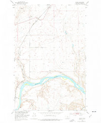
1953 Map of Verona
USGS Topo · Published 1976About this map
The Missouri River cuts a deep path through the Chouteau County landscape, anchoring a geography defined by its steep coulees and the infrastructure of the Great Northern railroad. The settlement of Verona is marked by its prominent grain Elevator, a testament to the local agricultural economy, while the small community of Virgelle sits further south along the tracks. This survey, conducted as part of the Department of the Interior program for the development of the Missouri River Basin, documents the transition from early river navigation to rail-and-road dominance. Significant historical sites include Coal Banks Landing (Site) and the Coal Banks Bridge, which provided essential crossings and river access. The terrain is deeply eroded, with drainage features like Coal Banks Coulee, Little Sandy Creek, and Jackson Coulee carving into the high plains surrounding the river valley.
Find a feature on this map
19 named features on this map. Tap any name to fly to it.
Don’t see what you’re looking for? This feature index may not catch every label — zoom into the map to look around manually.
Map Details
Editions of this 1953 Verona Map
2 editions found
Other maps of this area

1890 · Fort Benton
USGS Topo · 1:250,000

1892 · Fort Benton
USGS Topo · 1:250,000

1897 · Fort Benton
USGS Topo · 1:250,000

1906 · Lonesome
USGS Topo · 1:62,500

1919 · Big Sandy
USGS Topo · 1:125,000

1953 · Boggs Island
USGS Topo · 1:24,000

1953 · Verona
USGS Topo · 1:24,000

1953 · Big Bend School
USGS Topo · 1:24,000

1953 · Lonetree Coulee
USGS Topo · 1:24,000

1953 · Pilot Rock
USGS Topo · 1:24,000