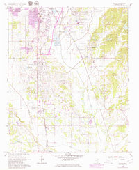
1966 Map of Verona
USGS Topo · Published 1979About this map
The southern periphery of Tupelo and the developing corridor south toward Verona dominate this landscape during a period of transition. The 1977 revisions, noted in purple, document the expanding residential and industrial footprint alongside established landmarks like the Tupelo National Fish Hatchery and the Itawamba Junior College (Vocational School). Transportation is defined by the crossing of the Gulf Mobile and Ohio and the St Louis - San Francisco railroads, which shaped the development of nearby Plantersville and Verona.
Find a feature on this map
46 named features on this map. Tap any name to fly to it.
Don’t see what you’re looking for? This feature index may not catch every label — zoom into the map to look around manually.
Map Details
Editions of this 1966 Verona Map
3 editions found

Other maps of this area

1921 · Tupelo
USGS Topo · 1:48,000

1923 · Tupelo
USGS Topo · 1:62,500

1955 · Sherman
USGS Topo · 1:62,500

1956 · Tupelo
USGS Topo · 1:250,000

1958 · Tupelo
USGS Topo · 1:250,000

1965 · Mooreville
USGS Topo · 1:24,000

1966 · Shannon
USGS Topo · 1:24,000
1966 · Nettleton
USGS Topo · 1:24,000

1966 · Troy SE
USGS Topo · 1:24,000

1966 · Evergreen
USGS Topo · 1:24,000