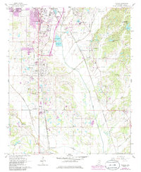
1966 Map of Verona
USGS Topo · Published 1986About this map
Tupelo and its southern neighboring communities of Verona and Plantersville show a mid-century landscape defined by rail corridors and educational expansion. The presence of the Itawamba Junior College (Vocational School) and the Agriculture Experiment Sta indicates a period of local investment in specialized training and science during the 1960s. Two major rail lines, the Gulf Mobile and Ohio and the St Louis - San Francisco, intersect the terrain, providing the backbone for the region's industrial and agricultural transport.
Find a feature on this map
38 named features on this map. Tap any name to fly to it.
Don’t see what you’re looking for? This feature index may not catch every label — zoom into the map to look around manually.
Map Details
Editions of this 1966 Verona Map
3 editions found

Other maps of this area

1921 · Tupelo
USGS Topo · 1:48,000

1923 · Tupelo
USGS Topo · 1:62,500

1955 · Sherman
USGS Topo · 1:62,500

1956 · Tupelo
USGS Topo · 1:250,000

1958 · Tupelo
USGS Topo · 1:250,000

1965 · Mooreville
USGS Topo · 1:24,000

1966 · Shannon
USGS Topo · 1:24,000
1966 · Nettleton
USGS Topo · 1:24,000

1966 · Troy SE
USGS Topo · 1:24,000

1966 · Evergreen
USGS Topo · 1:24,000