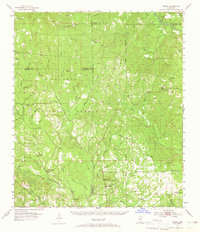
1954 Map of Vestry
USGS Topo · Published 1965About this map
The De Soto National Forest dominates this mid-century landscape, preserving a network of creeks and small settlements across the intersections of Stone, Harrison, George, and Jackson Counties. The Tchoutacabouffa River and Red Creek serve as primary drainage for the area, which was defined at the time by forestry and small-scale resource extraction, as evidenced by several Sand Pit sites and a Clay Pit. Community life centered around scattered rural congregations and family burial grounds, including Bonnie Chapel, Latimer Ch, and the Ramsey Cem. Early industry and infrastructure are represented by Cooper Mill in the north and several fire observation points like the Latimer Lookout Tower. The settlement of Vestry sits in the northeast corner near Tootle Ch, while the remote Rifle Range in the southwest suggests specialized land use during this era.
Find a feature on this map
70 named features on this map. Tap any name to fly to it.
Don’t see what you’re looking for? This feature index may not catch every label — zoom into the map to look around manually.
Map Details
Editions of this 1954 Vestry Map
4 editions found

Other maps of this area

1941 · Vancleave
USGS Topo · 1:62,500

1941 · Lucedale
USGS Topo · 1:62,500

1943 · Pascagoula
USGS Topo · 1:62,500

1943 · Lucedale
USGS Topo · 1:62,500

1943 · Vancleave
USGS Topo · 1:62,500

1944 · Vancleave
USGS Topo · 1:62,500

1947 · Wiggins
USGS Topo · 1:62,500

1947 · Benndale
USGS Topo · 1:62,500

1949 · Wiggins
USGS Topo · 1:62,500

1949 · Benndale
USGS Topo · 1:62,500