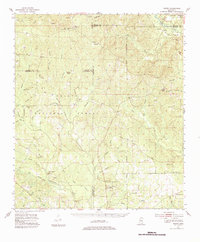
1954 Map of Vestry
USGS Topo · Published 1984About this map
DeSoto National Forest dominates this mid-century landscape in the Mississippi piney woods, where a network of creek branches and river bottoms dictated the early development of small logging and farming communities. The Tchoutacabouffa River winds through the central territory, joined by numerous tributaries like Tuzachonie Creek and Billie Bayou. Evidence of early industry appears at Cooper Mill and several Sand Pits, while the region's spiritual and social hubs are marked by isolated country churches such as Ramsey Chapel, Little Creek Ch, and White Plains Ch. Small settlements like Beatrice and Vestry anchor the corners of the quadrangle, connected by forest roads and narrow lanes. The presence of the University Lookout tower and Latimer Lookout Tower highlights the importance of timber management and fire surveillance within the sprawling national forest boundaries during this era.
Find a feature on this map
66 named features on this map. Tap any name to fly to it.
Don’t see what you’re looking for? This feature index may not catch every label — zoom into the map to look around manually.
Map Details
Editions of this 1954 Vestry Map
4 editions found

Other maps of this area

1941 · Vancleave
USGS Topo · 1:62,500

1941 · Lucedale
USGS Topo · 1:62,500

1943 · Pascagoula
USGS Topo · 1:62,500

1943 · Lucedale
USGS Topo · 1:62,500

1943 · Vancleave
USGS Topo · 1:62,500

1944 · Vancleave
USGS Topo · 1:62,500

1947 · Wiggins
USGS Topo · 1:62,500

1947 · Benndale
USGS Topo · 1:62,500

1949 · Wiggins
USGS Topo · 1:62,500

1949 · Benndale
USGS Topo · 1:62,500