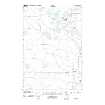
2010 Map of Victoria
USGS Topo · Published 2010About this map
Victoria is defined by its complex network of lakes and marshes at the start of the 21st century, where the community and local commerce center around the Victoria Post Office and the shores of Stieger Lake. The landscape transition from the developed town center to the surrounding rural reaches is marked by numerous water bodies, including the large Wassermann Lake and Lake Auburn. Local history is deeply etched into the land through a high density of religious and family burial grounds, such as the Lake Auburn Moravian Cemetary and the German Reformed Cemetery.
Find a feature on this map
75 named features on this map. Tap any name to fly to it.
Don’t see what you’re looking for? This feature index may not catch every label — zoom into the map to look around manually.
Map Details
Editions of this 2010 Victoria Map
This is the sole edition of this map. No revisions or reprints were ever made.
Other maps of this area

1905 · Minnetonka
USGS Topo · 1:62,500

1907 · Minnetonka
USGS Topo · 1:62,500

1953 · Saint Paul
USGS Topo · 1:250,000

1957 · Belle Plaine
USGS Topo · 1:62,500

1957 · Waconia
USGS Topo · 1:62,500

1957 · New Prague
USGS Topo · 1:62,500

1958 · Victoria
USGS Topo · 1:24,000

1958 · Mound
USGS Topo · 1:24,000

1958 · Lake Minnetonka
USGS Topo · 1:62,500
1958 · Shakopee
USGS Topo · 1:24,000